The elements of this page are licensed under the Creative Commons Attribution 4.0 International License (CC-BY-SA 4.0). See legal notices for more information.

Organization

WP1. Coordination
Project coordination
- Judicaël Picaut (Univ Eiffel)
- Arnaud Can (Univ Eiffel)
Steering Committee
- Judicaël Picaut (Univ Eiffel)
- Jeremy Ardouin (Wi6Labs)
- Erwan Bocher (CNRS)
- David Ecotière (Cerema)
- Mathieu Lagrange (CNRS/LS2N)
- Catherine Lavandier (UCP)
- Christophe Mietlicki (Bruitparif)
- Vivien Mallet (Inria)
- Stéphane Laime (Bouygues Energies & Services)
- Pierre Crépeaux (Ville de Lorient, advisory role)
Monitoring committee
- Judicaël Picaut (Univ Eiffel)
- Technical services of the city of Lorient
- Elected officials of the City of Lorient
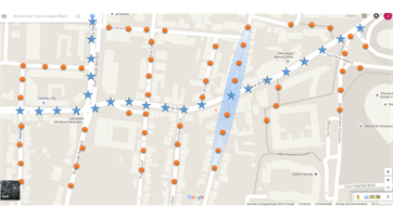
WP3. Measurement network
This task aims to produce a noise measurement network, relying on innovative technologies, which provides noise data that fulfil specified requirements. The first originality of this approach is that the network will be built by joining two communicating networks: (i) a wireless network (for “basic” noise measurements) and (ii) a wired network (for “advanced” noise measurements). The second originality is that the wired network is supported by an urban lighting network using the Citybox® technology developed by the partner Bouygues E&S, which constitutes an innovative use of this technology. This mixed-solution offers flexibility in the development of a noise measurement network, taking advantage of already deployed urban infrastructures (lighting network) for data transfer and power supply, with a possible extension of the wired network by using additional “remote sensors”.
This work package includes sensors development and testing, deployment on an experimental site, as well as data storage and post-processing
Reference

WP5. Characterisation of sound environments
The objective of the WP5 will consist in producing advanced noise maps, offering a better understanding of urban sound environment compared with mapping of classical noise indicators. Soundscape models that rely on automatic identification of scenes and sources will be proposed, in order to propose better acoustic models of outdoor soundscape quality. To the best of our knowledge, automatic inference of the soundscape quality is made in the literature by considering various statistics of pressure measurement. However, the very nature of the sound events are mandatory in order to better predict the soundscape quality from the audio, as for a human the qualitative aspect of the perceived sound greatly influences the overall quality. Based on recent studies in the field of Audio Event Detection (AED), these models will make it possible to predict the outdoor sound quality from the sensor recordings.
Reference
WP2. Data and Modelling
Many sources of errors have been identified when using existing noise prediction models, but are currently not quantified. As a consequence, the outputs of noise modelling are considered as “exact values”, while they are necessarily flawed and should be systematically associated with uncertainties.
In this context, the goal and the originality of the WP2 is to access to enhanced input data in order to a priori reduce uncertainties, and then, to study the relative influence of all those varying parameters on the final and global uncertainty on the noise predictions. This last operation can be achieved by developing a meta-model.
WP4. Data assimilation and network optimisation
This task aims to produce the best estimations of outdoor noise levels that can be derived from both numerical simulations, as generated in WP2, and observations from the monitoring network deployed in WP3. In other words, this task will merge simulations and observations in order to generate noise maps that are as close as possible to the “real” (in situ) noise levels. Scientific developments proposed in this WP on data assimilation, provide a major break, and represent an important originality, since such approach has never been used on the environmental noise context.
This work will include uncertainty quantification for the resulting estimations. The estimations will be in the form of noise maps with the same high spatial resolution as simulations. The minimum target is hourly noise maps, either for typical days (weekday, Saturday, Sunday, holidays) or for every single day within the experiment period. The proposed methods will be compatible with operational use, especially in terms of computational burden. Also, the task will perform the optimization of the sensor network in order for the resulting maps to be as accurate as possible. Since data assimilation for accurate monitoring of noise pollution is a new topic, different solutions should be investigated, by increasing the corresponding approach complexity.
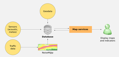
WP6. Integrative GIS platform
The objective of the WP6 is to develop an Integrative Geographical Information System Platform (IGISP) to facilitate data accessibility, its reuse and its exploitation to build new thematic maps. The IGISP implements the SDI concepts. The data formats and the data flows (raw or graphic representations) will be managed by open data standards.
The platform is organized around two components.
A single geospatial database aggregating all produced data. Data are heterogeneous, quantitative or qualitative. They are coming from different spatial and temporal scales and from various origins: measurements from in situ sensors, traffic data, survey, simulations, and computation of indicators. This geospatial database will driven by the Postgresql Relational Database Management Systems (RDDMS), extended with the PostGIS extension.
A map services application to diffuse thematic maps via the Internet using the standard WMS (Web Map Services). A particular attention will be paid on the cartographic Style Layer Descriptor. By experimenting a new cartographic server on the OrbisGIS platform, it will demonstrate how it is important to have syntactic portrayal interoperability operational with a mature open specification able to standardize the symbology code (map results). Since the current Symbology Encoding standard does offer limited capabilities for describing cartographic symbolizations (i.e. poor quality maps). Some recommendations will be proposed to improve this situation through more capabilities to customize the map symbology. Good practices will also describe to favour adoption of standards. Such propositions should lead to full cartographic portrayal interoperability, going further then basic styles to display the extra-noise indicators as accessibility (closest quiet zone…), exposure reduction tools (lowest sound exposure path) for the population, or other experimental indicators, like the Harmonica index developed in a EU Life project.